Basic
Worldview:
314
End Times Prophecy (Eschatology) Premillennial
Temple Study
Premillennial Temple Study Part 1
Premillennial
Temple Study Part 2
Premillennial Temple Study
Part 3
Premillennial Temple Study Part 4
Premillennial Temple Study Part 5
Premillennial
Temple Study Part 6
Premillennial Temple Study
Part 7
Premillennial Temple Study Part 8
Premillennial Temple Study Part 9
Premillennial
Temple Study Part 10
Premillennial Temple Study
Part 11
Premillennial Temple Study Part 12
Premillennial Temple Study Part 13
Premillennial
Temple Study Part 14
Premillennial Temple Study
Part 15
SECTION
TWO
The
Various Theories on the Site of the Temple
At
this point, some might ask what may seem to be a few obvious questions. Why do
we need to examine this issue? Dont we already know where the Temple
was? Wasnt it on the Temple
Mount? Hasnt this question
been answered already?
It
is true that, the question of where the Temple was located is generally considered to
be a closed issue. For example, the New International Standard Bible Encyclopedia
states:
It
is clear that the site of todays Dome of the Rock on Jerusalems
eastern hill marks the location of Solomons temple (as well as that of the
later structures of Zerubbabel and Herod); but
it is difficult to be more precise. The
New International Standard Bible Encyclopedia, quoted in The Temples that
Jerusalem Forgot, Ernest L. Martin, ASK Publications, P.O. Box 25000, Portland,
OR 97298-0990.
Copyright 2000 Ernest L. Martin, p. 109
However,
while the New International Standard Bible Encyclopedia does represent the conventional
point of view, there is actually a great deal more discussion regarding the Temples
location than is commonly percieved. In point of fact, there are several competing
theories on where the Temple was located.
At
a conference held in 1995 three of the most prominent, modern views were presented.
Chuck Missler, of Koinonia House ministry which sponsored the event, had the following
to say about the number of theories on the location of the Temple.
Thats at least
two theories, no, no, no, no, no
not two theories. Fourteen of them.
Chuck Missler, 1995, The Coming Temple, Presentation 1, 39:03-39:11 minutes, Koinonia House, http://store.khouse.org/...
Similarly,
Dr. Ernest L. Martin, who had once worked with the famous Israeli archeologist
Benjamin Mazar, comments similarly on the various theories on the location of
the Temple Mount.
(Because, Martins theories will be discussed throughout our presentation we will
provide some of his scholarly background.)
Dr.
Ernest L. Martin has taught history for 12 years at a college in England, been
the Chairman of the Department of Theology at another in California, has supervised over 450 college students at the most significant archaeological
excavation ever conducted in Jerusalem for two months each year for a period of
five years (and his archaeological educational program was featured in the Education
section of Time magazine for September 3, 1973)
The Temples that
Jerusalem Forgot, Ernest L. Martin, ASK Publications, P.O. Box 25000, Portland,
OR 97298-0990. Copyright 2000 Ernest L. Martin, back cover
Dr. Ernest L. Martin Between 1969
and 1973 Ambassador College
entered into an alliance with Hebrew University
in Israel which had been negotiated by Martin. This undertaking commenced
a five years archaeological excavation near the Western Wall of the Temple Mount
during which time he supervised 450 participating college students during the
summer months. The program gained mention in a TIME
magazine article
.The basis of this work began with the first visit by Martin
to Jerusalem in 1961 when he first met Professor Benjamin Mazar
and later his son, Ory,
wikipedia.org
Benjamin
Mazar Benjamin
Mazar (June 28,
1906 - September 9, 1995) was a pioneering Israeli
archaeologist
who shared the national passion for the archaeology of Israel that also attracts
considerable international interest due to the region's Biblical links. He is known for
his involvement in the identification and recovery of the Dead Sea Scrolls and
for leading the excavations at the most significant biblical site in Israel:
The temple mount (southern wall) in Jerusalem.
Universally recognized as the "dean of Biblical archaeologists of the 20th
century", Prof. Mazar was known as the founder of the academic science of
Geographical History. He is the author of more than 100 books about the bible,
biblical history and archaeology. For decades he served as the chairman of the
Israel
Exploration Society, which supervises all archaeological activities. wikipedia.org
In
his book, Martin makes several reports about the number of locations offered for
the Temple. We
should note that four of these theories did NOT located the Temple
on the platform that today is commonly called the Temple Mount.
in
modern times there have been at least SEVEN
different areas within the Haram enclosure that have rivaled each other as the
site for the Holy of Holies. Those seven
areas within the Haram are not the only contenders for the site of the Temples. There have been
four areas of Jerusalem
outside the perimeters of the Haram
esh-Sharif (accepted by people from the 4th century to the 11th century of our
era) that were also thought to be the site of the Temple. In all, this makes eleven different areas in very dissimilar
sections of the Haram and in various locations in Jerusalem that have been claimed to be the true
site. The Temples that Jerusalem Forgot, Ernest
L. Martin, ASK Publications, P.O.
Box 25000, Portland, OR 97298-0990.
Copyright 2000 Ernest L. Martin, p.109-110
The common use of the term Temple Mount is a reflection of the popular contemporary view(s)
that the Temple
was located on this large platform. However, since we will seek to establish the
Temples location
from historical data rather than from popular, modern conclusions, we will instead
refer to this structure as the Moriah Platform. More information on this important
archeological site will be discussed as we continue.
In
the pages that follow the above remark, Martin outlines the various theories that
have been put forward over the centuries for the site of the Temple.
However, today, only three or four major theories are regularly discussed in the
public forums. These theories deal with the overall location of the greater Temple
complex itself. Within some of these theories there is also some disagreement
over the specific location of particular structures within the arrangement of
the greater Temple
complex. These structures include the Temple
building itself, the Holy of Holies, the foundation stone, and the altar of sacrifice.
Tuvia
Sagiv, a spokesperson for one of the theories, outlines the basic differences
between todays most talked about views.
According
to the most traditional systems, the Temple
itself, the Holy of Holies was here. It means in this place. We see this wonderful
building the Dome of the Rock, which was built by the Arabs in the seventh century.
42:15 42:25 Some scholars say no, the rock
was not exactly the place of the Holy of Holies, but it was the place of the altar.
Some say no, the Temple itself was in the north. And there are
even some others who say it was in the south. Tuvia Sagiv, The Coming Temple,
Presentation 2, Koinonia House, 41 minutes and 55 seconds, http://store.khouse.org/store/...
According
to, you know there are a lot of ideas as to where it was exactly, the Holy of
Holies. You know there are a lot of problems [regarding] exactly where is the
Holy of Holies. Some say it was in the north. You know Professor Kaufmans theory.
Some say the Holy of Holies is the rock of the Dome. And some say that the rock
is the place of the altar. In our discussion,
I prefer to talk of the theory, Dan Bahats theory, that says that the Dome of
the Rock is the place of the Holy of Holies. Most of the archeologist, scientists, they
have taken the facts, how it looks, they have taken the literature sources put
them all together one another and say, Alright, the area itself is bigger than
whats written in the sources, so let us try and find where is the place of the
Temple Mount. Maybe its in the south. Maybe in the center. Maybe in the north.
Tuvia Sagiv, The Southern Location of the Temples, 5 minutes and 38 seconds, http://www.templemount.org/lectures.html
Of
the four major views on the location of the Temple, the first three of
these theories can be grouped together. Each of these three theories places the
Temples location somewhere within the bounds of
the Moriah Platform (the Haram ash-Sharif or Temple Mount)
where the Dome of the Rock and the Al-Aqsa Mosque are today. (As we said earlier,
we will use the term Moriah Platform so as not to confuse the issue or infer agreement
with any particular view before a thorough consideration of the facts has been
performed.)
Of these
three views, the Traditional View concludes that the Temple
was located at the Dome of the Rock. The chief proponents of this view today are
Dan Bahat, former chief architect for the Jerusalem District, and by Leen Ritmeyer,
whose position was most notably featured in the 1995 edition of the Biblical Archeological
Review.
Dan
Bahat is one of Israel's leading archaeologists and a senior lecturer
at the Land of Israel Studies at Bar-Ilan University.
He is an expert on the Temple Mount, Herod's Palace, and the 1,600- foot tunnel that
runs under the western retaining wall of the Temple Mount.
Christianity Today, The Dick Staub Interview: Dan Bahat
on Jerusalem Archaeology, January 1, 2003,
http://www.ctlibrary.com/...
Dan
Bahat served as Jerusalem district
archaeologist from 1978 to 1990; Dan Bahat, the former chief archeologist of
Jerusalem - Biblical archaeology conference highlights 'Naked Archaeologist,'
lost tomb, Mike Bell and Judy Rydberg, Issue date:
11/18/08, http://media.www.unogateway.com/...
DAN
BAHAT served as the district archaeologist for Jerusalem and has published extensively
on the city's history, including multiple articles for Biblical Archaeology
Review. In addition, he has excavated at Masada,
Tel Dan, Beth Shemesh, Safed and Beth-Shean, among other sites. He is currently a lecturer at the University of Toronto. The Jerusalem of Jesus product
info, http://www.easycart.net/...
Leen
Ritmeyer Leen Ritmeyer is a Dutch-born archaeological architect who currently lives and works in Wales,
having spent 22 years in Jerusalem from 1967-1989.
He holds the M.A. in Conservation Studies
from the Institute of Advanced Architectural Studies, University of York, England,
and the Ph.D. from the University of Manchester, England.
Ritmeyer is known for the "solid scientific research" he has done on
the structure and remaining elements of the Jewish Temple
in Jerusalem.
[1]
He has presented evidence for fixing the location of the Ark of the Covenant on the Foundation Stone.[2]
He has demonstrated that one of the steps leading to the Dome of the
Rock is actually the capstone of the pre-Herodian wall of the Temple Mount
platform. [3]
Ritmeyer is well known for his architectural models of the buildings of
ancient Jerusalem.
His models of the historical Jewish Temples have
been exhibited at museums including the Yeshiva University Museum in New York [4]
and the Siegfried H. Horn Museum.
wikipedia.org
A
second view, the Northern View, is championed by physicist Dr. Asher Kaufman.
According to this theory the Temple stood to the north of the Dome of the
Rock on the Moriah Platform.
Asher Kaufman - Assistant
Professor, Department of History, Degrees
B.A., M.A., Hebrew
University of Jerusalem; Ph.D., Brandeis
University, Research Profile: Kaufmans areas of specialization are the
modern history of Lebanon and
Syria
and the Arab-Israeli conflict. He is the author of Reviving Phoenicia: The
Search for Identity in Lebanon
(London: I.B.
Tauris, 2004) and of articles on Lebanese and Syrian nationalisms. He is currently
working on a new project focusing on boundaries, territoriality, conflict, and
identities in Lebanon, Syria,
and Israel. http://al.nd.edu/resources-for/...
Asher Kaufman (Ph.D.
Brandeis University,
2000) joined the University
of Notre Dame faculty in
August 2005. Prior to that, he taught at Hebrew
University, Jerusalem. From 2000 to 2004, he was a research fellow at the
Harry S. Truman Research Institute for the Advancement of Peace, and headed its
Middle East Unit in 2004-05. http://kroc.nd.edu/people/...
The
third view, the Southern Moriah Platform View, identifies a site directly adjacent
to the Western (or Wailing) Wall and places the Temple
to the south of the Dome of the Rock, between the Dome of the Rock and the Al-Aqsa
Mosque. This view is offered by Israeli architect Tuvia Sagiv.
Tuvia Sagiv, based in Tel Aviv, was born in Belgium 1947, comes from a religious
background. He completed his architecture
studies at Haifas
Technion, the Israel Institute of Technology in 1973. http://green-dense-burial.com/psabout.html
An
overview of these three main views is provided in audio presentations offered
by Koinonia House and can be found at the following web address: http://store.khouse.org/....
Additional presentations by Bahat, Kaufman, and Sagiv are also available online
at http://www.templemount.org/lectures.html.
Throughout this study we will make references to remarks made by these scholars
in their presentations regarding the location of the Temple. It should be noted that while these
three views differ from one another in their exact placement of the Temple, there is one thing
they all have in common. All three of these theories claim that the Temple was located somewhere
within the confines of the Moriah Platform.
The
fourth view that deserves attention differs from these three views because it
does not locate the Temple site within the Moriah Platform. The
view is offered by Dr. Ernest L. Martin in his book The Temples that Jerusalem Forgot. According to Martins thesis, the
Temple was not
located within the confines of the Moriah Platform at all. Instead, the Temple site was entirely
south of the Moriah Platform.
For
the purposes of our investigation we can group these four theories into two camps.
The first camp includes the views offered by Bahat/Ritmeyer, Kaufman, and Sagiv,
which all locate the Temple within the Moriah Platform. For this
reason we will refer to these theories as the Moriah Platform Views. In contrast,
we will refer to the view reflected in Martins work as the Gihon Spring View.
This will denote the theory that the Temples former
site was south of the Moriah Platform near the Gihon Spring and the archeological
area that is today known as the City of David.
In order to highlight
the divergence between these two main views it is helpful to get a basic idea
of the geographical differences that are implicit to their conclusions. (See illustrations
labeled: Jerusalem Geo Diagram, North Platform Diagram, Dor Site Diagram, South Platform Diagram, Gihon Site Diagram.)
Before
we proceed we want to express our indebtedness to the many biblical researchers,
historians, and archeologists who have studied this topic and dedicated their
lives and careers to its investigation (including those mentioned above.) In the
course of our own investigation, we have spent many long hours over several years
studying their work, tediously taking notes, and listening to hours of presentations.
In this way we have sought to learn from their expertise and effort in this field.
Much of the work that follows in this study was only possible through the work
of others. Not much of what we will present was discovered by our own research.
Rather we have sought to collect in a single, organized study the many issues
and evidences that others have brought to the table regarding the location of
the Temple. Throughout the study ahead, we will
continue to quote and reference the valuable work of these scholars. And we hope
that our presentation will be an accurate reflection of their positions as well
as the biblical, historical, and archeological data on the site of the Holy Temple.
Major
Sources for the Location of the Temple
Throughout
this study, we will refer to many biblical and historical sources as we build
our understanding of the Temple, its location, and its history. However,
there are a few main sources that deserve some mention up front. The two major
historical sources for information about the Temple are Josephus Flavius and the Mishnah.
A third source of information the Herodian
Temple is the New Testament.
Josephus Flavius
was a first century Jewish priest and historian who chronicled the history of
the Jewish people. His works include very detailed descriptions of the Jewish
Temples as well as the Roman siege and destruction of Jerusalem
in 70 AD. According to scholars on the subject of biblical Jerusalem,
Josephus writings are held in high regard as a reliable testimony of first century
Judaism and the Temple.
Josephus
Josephus (AD 37 c. 100), [2] also known as Yosef Ben Matityahu (Joseph,
son of Matthias) and, after he became a
Roman citizen, as Titus Flavius Josephus,[3] was a first-century Jewish historian
and apologist of priestly and royal ancestry who survived and recorded the destruction
of Jerusalem in AD 70.[4] His works
give an important insight into first-century Judaism. Josephus was an important
apologist in the Roman world for the Jewish people and culture, particularly at
a time of conflict and tension. He always remained, in his own eyes, a loyal and
law-observant Jew. He went out of his way both to commend Judaism to educated
Gentiles, and to insist on its compatibility with cultured Graeco-Roman thought.
He constantly contended for the antiquity of Jewish culture, presenting its people
as civilised, devout and philosophical. Eusebius reports that a statue of Josephus
was erected in Rome.[5] Josephus's two most important works are The Jewish War (c. 75) and Antiquities
of the Jews (c. 94).[6] The Jewish War recounts the Jewish revolt against Rome
(6670). Antiquities of the Jews recounts the history of the world from a Jewish
perspective. These works provide valuable insight into first century Judaism and
the background of early Christianity.[6] wikipedia.org
Josephus
Flavius
He has a problem with numbers of people to assume how many people
were in an area or how many people were killed.
But when he describes an area he is perfect.
In Massada, exactly as he wrote down, exactly we find the place. In Gamla, in
the Golan, the same thing, as he describes so we find it. Tuvia Sugiv, 1995,
The Coming Temple, Presentation 2, Koinonia House, 46 minutes and 47 seconds,
http://store.khouse.org/...
Every
one of you knows that in order to learn the Temple Mount, its location, its courts, and everything
you have got two basic sources, which can help you with that. The basic sources
are first of all, Josephus Flavius, which is extremely important. And to Josephus
Flavius, I will add, not as an independent source, I will add the Gospels and
Acts because there are so many small details, which are so important to the Temple
Mount like, and you will see how essential it is, Solomons portico, the court
of the Gentiles, the pinnacle, and so many other things, which are mentioned only
in the Gospels or in Acts, of the Beautiful Gate, for example, which is also important.
All those show up only in the Gospels, but when you take the Gospels youll see
that all the descriptions of the Gospels go very well along with Josephus Flavius.
It is identical. I will say, in this respect, the Gospels, of course, add more
detail. Now, on the other hand, the other one, which we
have is, of course, the Mishnah. Dan Bahat, The Traditional Location of
the Temples, 8 minutes and 48
seconds, http://www.templemount.org/lectures.html
Professor Mazar who expressed to me personally
that his own archaeological investigations proved that Josephus more often than
not was correct in his eyewitness accounts. 149, Footnote 149: Before his death three
years ago Professor Mazar was the Dean of Israeli archaeologists and past Rector
and President of Hebrew University, as well as a professional historian. I worked
personally with Professor Mazar at his major excavation at the western and southern
wall of the Hara mesh-Sharif in Jerusalem from 1969 to 1974. Under Professor
Mazar I directed the activities of 450 college students over that period of five
years at that dig. Ernest L. Martin, The Temples
that Jerusalem
Forgot, p. 112
The
second major source of information about the Temple is the Mishnah. The
Mishnah is a collection of Jewish oral teachings that was written down in approximately
200 AD. The Mishnah is the first section of the Talmud and it presents discussions
of the rabbis from the period after the Temple was destroyed in 70 AD.
Talmud The Talmud has two components: the Mishnah
(c. 200 CE),
the first written compendium of Judaism's Oral Law; and the Gemara (c. 500
CE), a discussion of the Mishnah and related Tannaitic
writings that often ventures onto other subjects and expounds broadly on the Tanakh. wikipedia.org
Mishnah The
Mishnah or Mishna is the first major written redaction
of the Jewish oral traditions called the "Oral Torah"
and the first major work of Rabbinic Judaism.[2]
It was redacted c. 200 CE by Judah haNasiTalmud, the persecution of the Jews and the passage of time raised
the possibility that the details of the oral traditions dating from Pharisaic
times (536 BCE70 CE) would be forgotten. It is thus named for being both the
one written authority (codex) secondary (only) to the Tanakh as a basis
for the passing of judgment, a source and a tool for creating laws, and the first
of many books to complement the Bible in a certain aspect
.The Mishnah reflects debates between 70-200
CE
by the group of rabbinic sages known as the Tannaim.[5]
- wikipedia.org
When
you want to study the later Temple
Mount you have got three main sources.
Which well divide into two and make two. One of them is Josephus Flavius without
whom we could never, never know as much as we know about the Temple Mount
as we know today. To Josephus Flavius, and let us form of Josephus Flavius an entity along with the New Testament
because in the Gospels and in Acts when you read about the deeds of Christ
himself, his disciples, or his family, the
description of the Temple Mount is identical to the description which we have
in Josephus Flavius. And from this
point of view we must remember always that they are almost of the same synonym
in the way they describe things the term they use. And one term only shows
up in the gospels and nowhere else. And this is to me so important, the court
of the Gentiles. This is really the essence of understanding the whole story,
is what is the court of the Gentiles. So
this is one source. And the second
thing is the mishnah. And I dont have to tell you so much, what is the mishnah
.The
mishnah is actually a collection of tractates which are commentaries and exegites
on the biblical law. Thus, it serves as a kind of the basis to the legal, Jewish religious
system. The one which is called halachot in Hebrew. This is the Jewish base
religious orthodox legal base of life to this very day. And again after saying
that I would like to mention that the mishnah
was edited, brought up to date, and published in the year 200 AD, which was 130
years after Herods temple was already destroyed, after the Temple was just a vision.
And this was really the end of it. So these
are the two things: Gospels, Acts, and Josephus Flavius, and the Mishnah. We
we have got to try and do is to juxtapose them and to try and to see how it does
work. Dr. Dan Bahat, 1995, The Coming Temple, Presentation 2, 26:50-31:36 minutes,
Koinonia House, http://store.khouse.org/...
There
are several points of interest regarding these major historical sources. The first
is that all three sources (Josephus, the Mishnah, and the New Testament) are of
Jewish origin. However, only two of them (Josephus and the New Testament) were
written during the period when the Temple was still
in existence by persons who were eyewitnesses of the Temple. Unlike Josephus and
the New Testament, the Mishnah wasnt recorded by first hand sources. Instead,
it was written down 130 years after the Temples destruction. As such, historical and
archeological practice would warrant that Josephus writings be given more weight
since they constitute an eyewitness account of the Temple
(and its destruction) during the period when the Temple itself still stood. The Mishnah is later
dating and while it is very valuable in this discussion, religious esteem for
the work should not result in its being given archeological or historical priority
over earlier, more direct sources (like Josephus).
Having
outlined the basic views of the Temples location, we will now proceed to the
historical and archeological data in order to examine the claims of these views.
As we examine each piece of evidence we will assess how that evidence relates
to the two major theories that we have now identified (the Moriah Platform Views
and the Gihon Spring View.)
The
Geography of Jerusalem
In
a historical inquiry of the nature we are involved in, we must recognize that
the last time the Temple
existed was nearly 2000 years ago. And the first time the Temple was built was nearly 3000 years ago.
Therefore, in order to understand where the Temple
would have stood in todays Jerusalem we must first
understand where Jerusalem
was both 3000 and 2000 years ago in relation to todays geography. Then we must
identify where the Temple (and various other structures)
were in relation to the geography of the Jerusalem that existed at those times. Once
we accomplish both of these tasks then we will be able to identify where the Temple site was in terms
of todays city.
Twenty-first
century Jerusalem
is a vast city spread over 48 square miles.
Jerusalem
Jerusalem is the capital[iii]
of Israel
and its largest city[2]
in both population and area,[3]
with a population of 747,600 residents over an area of 125.1 square kilometres (48.3 sq mi) if
disputedEast Jerusalem
is included. wikipedia.org
The
area surrounding what is known today as the Old City
is shown in this image generously provided by BiblePlaces.com. (See image Jerusalem Photo.)
In the photo, north is towards the upper left-hand corner, south is toward the
lower right-hand corner, west is toward the left and east is toward the right.
The
next image, is the same photograph, but includes overlays showing the major areas
of Jerusalem today.
(See Jerusalem Today.) The tan colored box highlights the area of the Moriah
Platform (Haram ash-Sharif, the Temple Mount.)
Within this tan area are the famous Islamic shrines of the Dome of the Rock and
the Al-Aqsa Mosque.
The
blue area to the left of the Moriah Platform shows the location of the Wailing
Wall and Kotel area. Likewise, the blue area below the Moriah Platform designates
the archeological site that is referred to as the City of David.
The white area on the lower, right-hand side of the page denotes the largely Arabic
neighborhood of Silwan (or Kfar Shiloah). Opposite this, the white highlighted
section in the upper left-hand portion of the page shows the area contained within
the walls of what is today known as the Old City.
This area, today
called the Old City,
does not necessarily denote the oldest or most ancient part of Jerusalem.
Instead this walled-in area was actually only sectioned off in the sixteenth century
AD by Sultan Suleiman the Magnificent.
Western Wall - Ottoman period 15171917 In 1517 the Turkish Ottoman Empire
under Selim I conquered Jerusalem
from the Mamluks
who had held it since 1250. The Ottomans had a benevolent attitude towards the
Jews, having welcomed thousands of Jewish refugees who had recently been expelled
from Spain
by Ferdinand II of Aragon and Isabella of Castile in 1492. SultanSuleiman the Magnificent was so taken with
Jerusalem and its plight that he ordered a magnificent
fortress-wall built around the entire city, today's Old City wall. wikipedia.org
The City
of David The City of David, also known as the Ophel (perhaps meaning "fortified hill") is
the name of the narrow promontory beyond the southern edge of Jerusalem's
Temple Mount
and Old City, with the Tyropoeon Valley
(valley of the cheesemakers) on its west, the Hinnom valley
to the south, and the Kidron Valley on the east. The previously deep
valley (the Tyropoeon) separating the Ophel from what is now referred to as the Old City of Jerusalem currently
lies hidden beneath the debris of centuries. Despite the name, the Old City of Jerusalem dates from a much later
time than the settlement in the City of David, which is generally considered to
have been the original Jerusalem. wikipedia.org
The
main geographic features of the ancient city of Jerusalem are three major
mountain ridges running north to south and three major valleys. On the eastern
side of the city is the ridge known as the Mount of Olives.
Just to its west is the Kidron
Valley. West of the Kidron
is the central ridge of Jerusalem, commonly referred
to as Mount Moriah
or the Moriah ridge. To the west of the Moriah ridge is the area of the Tyropoeon Valley
which has been filled in over centuries of destruction and rebuilding. West of
the Tyropoeon Valley is the western ridge. To the south
running from the west towards the Kidron
Valley is the Valley of Hinnom.
Psalm
125:2 As the mountains are round about Jerusalem, so the LORD
is round about his people from henceforth even for ever.
Jerusalem
Jerusalem is situated on the southern spur of a plateau
in the Judean Mountains, which include the Mount of Olives (East) and Mount
Scopus (North East).
The elevation of the Old City is approximately 760 m (2,500 ft).[98] The whole of Jerusalem is surrounded by valleys and dry
riverbeds (wadis). The Kidron, Hinnom,
and Tyropoeon Valleys intersect in an area just south of the Old City of Jerusalem.[99]
The Kidron Valley
runs to the east of the Old City and separates the Mount of
Olives from the city proper. Along the southern side of old Jerusalem
is the Valley of Hinnom, a steep ravine associated in biblical eschatology
with the concept of Gehenna or Hell.[100] The Tyropoeon valley commenced in the northwest near the Damascus Gate,
ran south-southeasterly through the center of the Old City down to the Pool of
Siloam, and divided the lower part into two hills, the Temple Mount to the east,
and the rest of the city to the west (the lower and the upper cities described
by Josephus). Today, this valley is hidden by debris that has accumulated
over the centuries.[99] wikipedia.org
In his texts, which we will examine, Josephus refers to the Tyropoeon Valley by the name the Valley of the Cheesemakers
(Cheesemongers).
Tyropoeon Valley Tyropoeon
Valley (i.e., "Valley of the Cheesemakers")
is the name given by Josephus the historian (Wars 5.140) to the valley - wikipedia.org
These
basic geographic and topographic areas are identified in the same photo we looked
at earlier, but with overlays showing the ridges and valleys. (See image Jerusalem Hills Valleys.) In the image, the valleys are labeled and highlighted in yellow. The mountain
ridges are labeled and highlighted in blue. These areas are for general identification
and familiarization with the geography of the city. We have taken the effort to
ensure consistency with other maps of the city, but they are not meant to be perfect
historical, geographical, or topographical representations.
The
Temple was Located on the Moriah Ridge
The
bible informs us that that Solomon built the Temple on Mount
Moriah.
2 Chronicles 3:1 Then Solomon began to build the house of the LORD at Jerusalem
in mount Moriah, where the LORD appeared
unto David his father, in the place that David had prepared in the threshingfloor of Ornan the Jebusite.
Josephus
believed that the Temple was, in fact, built upon the same mountain
where Abraham went to sacrifice Isaac.
1.
Accordingly he commanded him to carry
him to the mountain Moriah, and to build an altar, and offer him for a burnt-offering
upon it for that this would best manifest his religious disposition towards him,
if he preferred what was pleasing to God, before the preservation of his own son.
2.
Now Abraham thought that it was not right to disobey God in any thing, but that
he was obliged to serve him in every circumstance of life, since all creatures
that live enjoy their life by his providence, and the kindness he bestows on them.
Accordingly he concealed this command of God, and his own intentions about the
slaughter of his son, from his wife, as also from every one of his servants, otherwise
he should have been hindered from his obedience to God; and he took Isaac, together
with two of his servants, and laying what things were necessary for a sacrifice
upon an ass, he went away to the mountain. Now the two servants went along with
him two days; but on the third day, as soon as he saw the mountain, he left those
servants that were with him till then in the plain, and, having his son alone
with him, he came to the mountain. It was
that mountain upon which king David afterwards built the temple. (28)
Josephus, Antiquities, Book 1, Chapter 13
However,
Genesis 22s account of Abraham and the sacrifice of Isaac, informs us that the
area of Jerusalem was actually within an area known
as the land of Moriah.
According to Genesis 22, the land
of Moriah had several mountains.
Genesis 22:2 And he said, Take now thy
son, thine only son Isaac, whom thou lovest, and get thee into the land of Moriah; and offer him there
for a burnt offering upon one of the mountains which I will tell thee of.
So,
God told Abraham to sacrifice his son Isaac on one of these mountains in the land of Moriah. And Solomon later built the Temple on a mountain
of Moriah. But as we have
seen ancient Jerusalem
had several mountain ridges. Which of the three main mountain ridges of the land of Moriah
was the Temple
built on? Was it the western ridge, the central ridge, or the Mount
of Olives?
Josephus
explains which of the mountain ridges the Temple was built on. According
to his description, the Temple was located on a
peak east of the Tyropoeon
Valley. This was across from
the western ridge where the Upper
City was located during the
later Old Testament period. This means that the Temple was built somewhere on the Moriah ridge.
1.
THE city of Jerusalem was fortified
with three walls, on such parts as were not encompassed with unpassable valleys;
for in such places it had but one wall. The city was built upon two hills, which are
opposite to one another, and have a valley to divide them asunder; at which
valley the corresponding rows of houses on both hills end. Of these hills, that which contains the upper
city is much higher,
.But the other
hill, which was called "Acra," and sustains the lower city, is of the
shape of a moon when she is horned; over against this there was a third hill,
but naturally lower than Acra, and parted formerly from the other by a broad valley.
However, in those times when the Asamoneans reigned, they filled up that valley
with earth, and had a mind to join the city to the temple. They then took off
part of the height of Acra, and reduced it to be of less elevation than it was
before, that the temple might be superior to it. Now the Valley of the Cheesemongers,
as it was called, and was that which we told you before distinguished the hill
of the upper city from that of the lower, extended as far as Siloam; for that
is the name of a fountain which hath sweet water in it, and this in great plenty
also. But on the outsides, these hills are surrounded by deep valleys, and by
reason of the precipices to them belonging on both sides they are every where
unpassable. Josephus, Wars of the Jews, Book 5, Chapter 4 THE DESCRIPTION OF JERUSALEM., Paragraph
1
However,
Mount Moriah is actually a ridge containing several
peaks.
The
topographic map shows that Mount Moriah
is not a single peak, but an elongated ridge which commences to rise at its Southern
end at the junction of the Kidron and Hinnom Valleys, at the original City
of David, (elevation approximately 600 meters). The ridge then climbs in elevation to a maximum
of 777 meters just Northeast of the present Damascus
Gate of the Old
City. The Temple
Mount, prominent in most photos of Jerusalem occupies an area
of about 45 acres. However the elevation of the bedrock outcropping on the Temple Mount
within the Dome of the Rock Moslem shrine is only 741 meters. http://www.templemount.org/moriah2.html
So,
we can see that the Temple was located on the central
ridge of Jerusalem which is called the Moriah ridge or Mount
Moriah. As we continue we will seek to
determine exactly where on the Moriah ridge the Temple was located.
David,
the Threshing Floor, and the Site of the Temple
The
site of the Temple
was first identified by King David as a threshing floor owned by Ornan the Jebusite
(2 Samuel 24:18-25, 1 Chronicles 21:15-28, 2 Chronicles 3:1).
1 Chronicles 21:15 And God sent an
angel unto Jerusalem
to destroy it: and as he was destroying, the LORD beheld, and he repented
him of the evil, and said to the angel that destroyed, It is enough, stay now
thine hand. And the angel of the LORD stood
by the threshingfloor of Ornan the Jebusite. 16 And David lifted up his eyes,
and saw the angel of the LORD stand between the earth and the heaven, having
a drawn sword in his hand stretched out over Jerusalem.
Then David and the elders of Israel, who were clothed in sackcloth,
fell upon their faces.
2 Chronicles 3:1 Then Solomon began
to build the house of the LORD at Jerusalem in
mount Moriah,
where the LORD appeared unto David his father, in the place that David
had prepared in the threshingfloor of Ornan the Jebusite. 2 And he began to build in the second day
of the second month, in the fourth year
of his reign.
1.
Accordingly he commanded him to carry him to the mountain Moriah, and
to build an altar, and offer him for a burnt-offering upon it for that this would
best manifest his religious disposition towards him, if he preferred what was
pleasing to God, before the preservation of his own son.
2. Now Abraham thought
that it was not right to disobey God in any thing, but that he was obliged to
serve him in every circumstance of life, since all creatures that live enjoy their
life by his providence, and the kindness he bestows on them. Accordingly he concealed
this command of God, and his own intentions about the slaughter of his son, from
his wife, as also from every one of his servants, otherwise he should have been
hindered from his obedience to God; and he took Isaac, together with two of his
servants, and laying what things were necessary for a sacrifice upon an ass, he
went away to the mountain. Now the two servants went along with him two days;
but on the third day, as soon as he saw the mountain, he left those servants that
were with him till then in the plain, and, having his son alone with him,
he came to the mountain. It was that mountain upon which king David
afterwards built the temple. (28)
Josephus, Antiquities, Book 1, Chapter 13
When
King Solomon built the Temple,
his temple mount, now I speak already about, lets say about artificial features.
The thing he did was to build a temple on top of Mount Moriah,
and he surrounded, or rather ground, that mount with walls because it was outside the city as you all know.
It was the threshing floor or Araunah the
Jebusite. Thats where King David built the altar. And this is the place where later King Solomon built the Temple. Dr. Dan Bahat, 1995, The Coming
Temple, Presentation 2, 25:00-26:20 minutes, Koinonia House, http://store.khouse.org/...
A
threshing floor requires even ground at an elevated spot so that chaff can be
effectively separated from the heads of the grain when tossed into the wind. Even
ground was necessary so that the separated grain could be collected without having
to tediously fish it out of cracks or rocky terrain where it had fallen.
A
threshing floor is a specially flattened
surface made either of rock or beaten earth where a farmer would thresh
the grain
harvest.
The threshing floor was either owned by the entire village or by a single family.
It was usually located outside the village in a place exposed to the wind. wikipedia.org
Threshing
is the process of loosening the edible part of cereal grain from the scaly, inedible
chaff that surrounds it. It is the step in grain preparation before winnowing,
which separates the loosened chaff from the grain. Threshing does not remove the
bran from the grain. Threshing may be done by beating the grain using a flail
on a threshing floor. However, in developed areas it is now mostly done by machine,
usually by a combine harvester, which threshes as well as harvesting the plant
and cleaning the grain). Another traditional method of threshing is to make donkeys or oxen walk
in circles on the grain on a hard surface. A modern version of this in some
areas is to spread the grain on the surface of a country road so the grain may
be threshed by the wheels of passing vehicles. wikipedia.org
Josephus
records that the Temple site was, in fact, a level area at the
top of a strong hill. He states that this plain at the top of the hill was large
enough to place the Temple
building and altar on.
1.
NOW this temple, as I have already said,
was built upon a strong hill. At first the plain at the top was hardly sufficient
for the holy house and the altar Josephus, Wars of the Jews, Book 5, Chapter
5, Paragraph 1
The
hill was a rocky ascent, that declined by degrees towards the east parts of the
city, till it came to an elevated level. This hill it was which Solomon, who was
the first of our kings, by Divine revelation, encompassed with a wall; it
was of excellent workmanship upwards, and round the top of it. Josephus, Antiquities, Book 15, Chapter 10
Solomons
Temple building
was 60 cubits long by 20 cubits wide (90 feet by 30 feet). Outside the Temple
building itself was a courtyard where the brazen altar of sacrifice was placed.
This altar was 20 cubits (30 feet) square in size.
2 Chronicles 3:3 Now these are the things wherein Solomon was instructed for the building of
the house of God. The length by cubits after the first measure was threescore
cubits, and the breadth twenty cubits.
1 Kings 6:2 And the house which
king Solomon built for the LORD, the length thereof was threescore cubits,
and the breadth thereof twenty cubits, and the height thereof thirty cubits.
20 And the oracle in the forepart was
twenty cubits in length, and twenty cubits in breadth, and twenty cubits in the
height thereof: and he overlaid it with pure gold; and so covered the
altar which was of cedar.
The
total length necessary to accommodate Solomons Temple and the court of the
priests where the bronze altar was placed would have been over 100 cubits long.
The rock beneath the Dome of the Rock is a much smaller area measuring only 60
by 40 feet (18.2 by 12.2 meters). There is a ledge on the southern side of the
rock with a caved area inside. Likewise, around the rock the ground slopes away
to lower elevations.
Herod's
Temple - In the
centre of the dome there is a bare, projecting rock, the highest part of Moriah
(q.v.), measuring 60 feet by 40 standing
6 feet above the floor of the mosque, called the sahkra, i.e., "rock."
- Easton's Bible
Dictionary
Foundation
Stone The Foundation Stone (Hebrew:
translit.
Even haShetiya) or Rock
(Arabic:
translit.
Sakhrah, Hebrew: translit.:
Sela) is the name of the rock at
the heart of the Dome of the Rock in Jerusalem
.The rock is located
an artificial platform
built by Herod the Great on top of vaults over a hill,
generally believed to be Mount Moriah. The Rock
constitutes the peak of this now hidden hill, which is also the highest in early
biblical Jerusalem, looming over the City of David,
and hence the Rock is one of the highest points of the Old City.
wikipedia.org
Foundation Stone Dimensions Although the rock is part of the surrounding bedrock,
the southern side forms a ledge, with a gap between it and the surrounding ground; - wikipedia.org
Likewise,
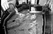
the rock beneath the Dome of the Rock has a rugged and uneven surface. A
great picture of the rock itself is available online at http://en.wikipedia.org/wiki/....
Since the picture is public domain we have also include the image for reference
with this article. (See The Rock Under the Dome image.) As the photograph clearly
shows, the condition of the rock surface today would not be suitable for threshing
grain.
These
facts show that the rock beneath the Dome of the Rock does not fit the biblical
or historical descriptions of the threshing floor where Solomon built the Temple. The rock under the
Dome of the Rock is not large enough. The ground around it is not level. And the
surface of the rock is not even, but quite rugged and unsuitable for a threshing
floor.
Additionally,
archeologist Leen Ritmeyer has pointed out man-made carvings on the surface of
the rock. He believes these carvings were part of the construction of the Holy
of Holies.
The rock has several human-made cuts in its surface;
these are generally attributed to the Crusaders,
whose frequent damage to the rock was so severe that the Christian kings of Jerusalem finally put
a marble slab over the rock to protect it (the marble slab was later removed by
Saladin).
More recently, there has been speculation
that several man-made features of the rock's surface may substantially predate
the Crusaders. Archaeologist Leen Ritmeyer
noticed that there are sections of the rock cut completely flat, which north-to-south
have a width of 6 cubits, precisely the width that the Mishnah
credits to the wall of the Holy of Holies,
and hence Ritmeyer proposed that these
flat sections constitute foundation trenches on top of which the walls
of the original temple were laid
.The bedrock near the Rock shows several signs
of having been quarried, and these clean edges and square cuts, could simply have
been a result of such activity. wikipedia.org
However,
biblical texts indicate that no iron tools were used at the Temple
site.
1 Kings 6:7 And the house, when it was
in building, was built of stone made ready before it was brought thither: so that there was neither hammer nor axe nor
any tool of iron heard in the house, while it was in building.
And
Asher Kaufman points to Mishnaic teaching that iron tools could not be used on
the altar.
I
should like to end by referring to a kind of a philosophical statement in Middot,
from chapter 3. I think it is particularly important these days when the United States and New York and here unfortunately, peoples lives
are being lost daily. And it says there,
about no iron being contacted with the altar. The altar had to be built with unhune
stones. Dr. Asher S. Kaufman, The Northern Location of the Temples, 46 minutes and 18
seconds, http://www.templemount.org/lectures.html
If
the rock under the Dome of the Rock does have carvings from biblical times these
prohibitions may, in fact, indicate that the Dome of the Rock it is not the site
of the Temple
building or the altar. These reasons constitute evidence that the rock beneath
the Dome of the Rock is not the site of the Temple or the altar. Its area is too small and
its surface is too rugged to be the threshing floor where Solomon built the Temple.


